






How Tall Is Mount Everest? Inside the 2020 Remeasurement
Mount Everest's official height became 8,848.86 m after Nepal and China jointly announced a remeasurement on 8 December 2020. This explains why Nepal measured the mountain itself, why snow height and rock height give different numbers, how the geoid complicates the idea of 'above sea level', what the 2019–2020 survey involved, and why the small change in the figure is about method rather than the mountain growing.

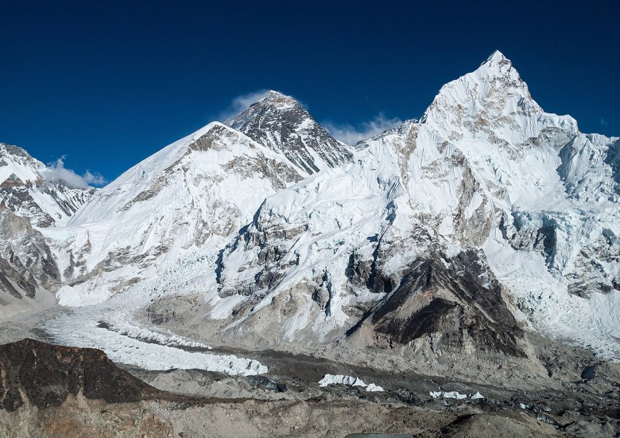
For most of the last century, the answer to "how tall is Mount Everest" was 8,848 metres. That number was printed on maps, taught in schools and repeated in climbing books. Then on 8 December 2020, Nepal and China jointly announced a revised figure: 8,848.86 m. The number barely moved. The work behind it changed a lot about how the mountain is measured.
Why Nepal decided to measure Everest itself
The 8,848 m figure that everyone quoted did not come from Nepal. It came out of Indian survey work, at a time when the Survey of India was mapping the Himalaya and Nepal did not have an equivalent national measurement of its own most famous landmark. That always sat awkwardly in Kathmandu.
The 2015 Gorkha earthquake gave the project a practical push. The quake reshaped slopes and shifted ground across central Nepal, and people began asking, reasonably enough, whether the world's highest summit had been affected. Satellite data and geological studies suggested any change to the summit itself was probably small, but "probably" is not what a national survey department wants to publish. So Nepal's Survey Department set out to measure the mountain properly, using its own instruments and its own reference points.
Fieldwork ran through 2019 and into 2020. It was not a quick trip: teams worked on the summit, installed receivers at lower elevations, ran survey lines across the country and collected gravity readings at many points. China carried out its own measurement in parallel, and the two countries eventually agreed to publish a single joint figure rather than two competing ones.
Two numbers, two methods
Most arguments about Everest's height were never really about the mountain. They were about where you stop measuring and what you measure from.
Snow height versus rock height
Everest has a permanent snow cap. Measure to the top of the snow and you get one number. Measure to the rock underneath and you get a lower one. Both are defensible; they just answer different questions. China's earlier official height, 8,844.43 m, was a rock height. Other measurements had taken the snow surface. That single disagreement accounts for most of the gap between the figures circulating before 2020. The height announced in 2020 is a snow height, and Nepal used ground-penetrating radar to estimate how deep that snow sits so the result could be stated consistently.
Above what sea level, exactly?
Satellite positioning gives you a height above a mathematical ellipsoid, a smooth model of the Earth's shape. That is not the same as height above sea level. Sea level is lumpy, because the Earth's gravity field is uneven: dense rock pulls the water surface up in some places and lets it dip in others. The imagined surface that mean sea level would make if you extended it under the continents is called the geoid.
To turn a GPS height into a published height, surveyors have to know the gap between the ellipsoid and the geoid at that exact spot. That gap is not a constant. It has to be measured, which is why the Everest project involved gravity surveys across Nepal and not just a receiver on the summit. Skip that step and your answer can be off by many metres, which is a lot when you are arguing about centimetres.
What the 2019–2020 survey actually involved
The work combined several techniques. Surveyors placed GNSS receivers on the summit and at points along the approach, measuring satellite signals to fix positions very precisely. They ran levelling lines, the slow traditional method of carrying a height from one benchmark to the next, to tie the mountain into Nepal's national height network. They took gravity readings to build a local picture of the geoid. Ground-penetrating radar was used to gauge snow depth at the top.
Getting a receiver to the summit and keeping it running long enough to be useful is its own small expedition. It has been done before, by other teams, but doing it as part of an official national survey, with the data published and reconciled with a neighbouring country's results, was new.
The 8 December 2020 announcement
The joint announcement was made in Kathmandu by the governments of Nepal and China. The agreed figure was 8,848.86 m, roughly 29,031.7 feet. That is a bit under a metre higher than the old 8,848 m, and more than four metres higher than China's 2005 rock-height figure. The difference is not a story about the mountain suddenly growing. It is mostly a story about agreeing on a method and then measuring very carefully.
The earlier measurements, briefly
Everest's height has been revised repeatedly, and each revision tells you as much about the surveyors as the summit.
In the mid-nineteenth century, surveyors with the Survey of India computed the height from triangulation and arrived at 29,002 feet, announced in 1852. The calculation is often credited to Radhanath Sikdar, a Bengali mathematician working for the survey. That attribution is a tradition rather than a documented certainty, and historians have argued over it for years.
Indian surveys in the 1950s settled on 8,848 m, and that figure stayed on maps for the rest of the century. China's 1975 measurement gave 8,848.13 m. A 1999 American GPS-based effort produced a slightly higher number again, partly because it measured to the snow surface. China's 2005 remeasurement returned 8,844.43 m, explicitly as a rock height. Each of these was a serious piece of work; they simply did not share a definition.
Treat all of these as historical records. The current official figure, as jointly announced by Nepal and China, is 8,848.86 m.
Is Everest growing?
Yes, in a geological sense, and by an amount no survey announcement will ever capture. The Himalaya are still being pushed up as the Indian plate drives into Asia, and the range rises by millimetres per year while erosion wears it down from above. Whether the summit gains or loses height in any given decade depends on the balance between those processes and on earthquakes, which can shift things up or down without warning.
What that means in practice: the gap between 8,848 m and 8,848.86 m is not evidence that the mountain grew half a metre in sixty-odd years. Almost all of it comes from better instruments, a defined convention about snow, and a proper geoid model. Anyone claiming Everest is climbing a few centimetres a year is describing tectonics, not the official height, and the two should not be mixed up.
Will the number change again?
Possibly, eventually. Heights are not eternal facts; they are measurement results, and they get revised when methods improve or when the ground moves enough to matter. A future remeasurement would need the same things the 2020 one had: a clear definition of what is being measured, a gravity-based reference surface, and agreement between the countries that share the mountain. For now, 8,848.86 m is the figure to quote, and it comes with a date attached.
What's Your Reaction?