


Greater Nepal and the Sugauli Treaty: What the Record Shows
Greater Nepal is an activist claim, not official policy. What the Sugauli Treaty of 1816 says, why Kalapani stays disputed, and where the record runs out.

Search for "Greater Nepal" and you get maps. Big ones, usually in orange or red, with a boundary running a long way west of where it runs today. The maps are easy to find. The paperwork behind them takes longer, and that gap between map and document is where this piece sits.
What the phrase actually refers to
Greater Nepal is not state policy. It is a claim advanced by activists and pressure groups rather than by a single body. The Greater Nepal Nationalist Front is the best known of them and has published maps and campaigned for years, but it does not speak for everyone who uses the phrase, and nobody does.
The argument runs roughly like this: Nepal's present territory was fixed by a treaty signed under military pressure in the early nineteenth century, the country held more ground before that war, and the larger boundary is the rightful one. That is the shape of it. The detail gets slippery, because different advocates draw the line differently. Some mean the full pre-war extent. Others mean particular patches along the western edge. No agreed statement defines what a larger Nepal would look like on the ground, and that vagueness is one reason the term is hard to pin down. The Nepali phrase brihat nepal covers the same idea under another name.
On status, be plain. No government in Kathmandu has adopted the claim as official policy. The official position is the map published in 2020, which is a separate and much narrower thing.
Why the Sugauli Treaty matters so much
The Treaty of Sugauli ended the Anglo-Nepalese War of 1814 to 1816. It was signed at Sugauli on 2 December 1815 and ratified by the Nepali side in March 1816. That gap is why it is remembered as the Sugauli Treaty of 1816: the signing came first, the ratification made it binding.
Whatever else is disputed about it, this is not. Almost every later argument about Nepal's western and eastern limits is anchored to that document. It is where the modern outline of the country was written down, between two very unequal parties.
The clause carrying the weight is the one describing the western boundary by a river. If a boundary is defined by a river, then the question of where that river begins becomes the whole case. A line drawn from a source is only as precise as the identification of the source, and in high mountain terrain that is not a trivial matter.
The wording problem nobody escapes
Editions of the treaty, and translations made from them, do not always read identically. A phrase that fixes a line in one rendering can look ambiguous in another. That is normal for documents of that age, and it is why careful writing on the subject names the edition and the translator.
This article does not quote the boundary clause, for that reason. A quotation is worth something only when the edition it came from, the translator's name and the date arrive with it. A sentence lifted from a secondary website proves that someone typed it, nothing more. Until a named, dated text is in front of you, treat any verbatim quotation you meet on this subject as unverified.
Kalapani, Lipulekh and Limpiyadhura
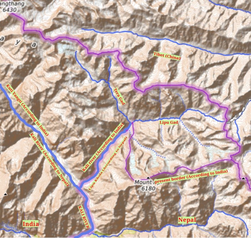
Three names sit at the head of the Mahakali in the far west: Kalapani, Lipulekh and Limpiyadhura, all covered in our page on the Kalapani dispute. Nepal's official map places all three inside Nepali territory. India treats the area as its own. That is the disagreement in one sentence.
One dated fact is worth carrying, with a caveat attached. India's military presence in the Kalapani area goes back to 1962, when posts were established around the time of its border war with China. Accounts of individual posts differ in detail, so hold the year loosely at that level. The broader point holds: this is more than six decades of facts on the ground, which is why the dispute is not a matter of reading an old clause correctly and then moving on.
Area figures get quoted for the tract. Treat them with caution. A number without a named survey, a stated method and a date is a number someone chose, and a bare figure is the easiest thing on this topic to repeat and the hardest to defend. The three place names are safer ground than a square-kilometre count.
The 2020 map and the amended schedule
In May 2020 the government of Nepal published a new official map that included the three areas. In June, parliament amended Schedule 1 of the constitution so that the constitutional description of the country's territory matched the map. Both are matters of public record, and they are why the subject moved from historical argument into constitutional text.
What has happened since, in terms of talks between the two governments and the day-to-day use of the amended map in official business, is not something this article will characterise. Statements about the present state of play go stale quickly and are easy to repeat without checking. For the administrative picture the map sits inside, see our guide to the provinces of Nepal.
What the record carries, and where it thins out
The record carries the treaty, its two dates and its broad purpose. It carries the 2020 amendment and the geography of the three named places. On two questions it carries much less than people assume: the precise line the boundary clause requires on the ground, and the pre-war boundary, where the cartographic record is thin and was never made to the standard a modern boundary case would demand.
None of that means the subject is unreadable. It means the confident maps and the confident rebuttals are both running ahead of the documents.
Four questions to ask of any map or article
Who made it, and in what capacity. What date is attached to it. What document or survey it was drawn from. And where the original is held. If a page cannot answer those four, it is illustrating an argument rather than documenting a boundary.
You will not find a map reproduced here, and that is deliberate. Drawing a boundary line, in a piece about a contested boundary, makes a statement whether or not the caption admits it. Nothing in this article asserts or endorses any boundary. The question under discussion is what the documents support, and the honest answer is this: less than the bold maps suggest, and more than enough to be worth reading properly.
What's Your Reaction?